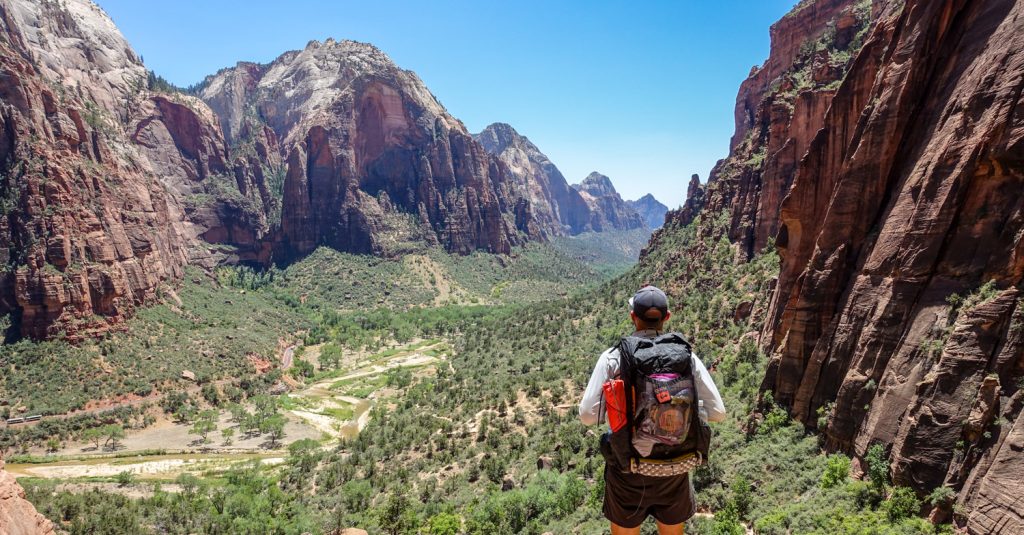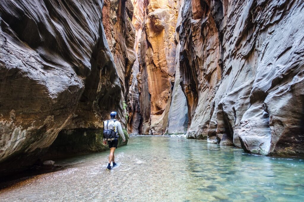
One of the nation’s deepest and longest slot canyons, The Narrows is the consummate epic adventure – and one of the most popular hikes in Zion National Park. Backpacked from top to bottom, the route begins at Chamberlain’s Ranch Trailhead and ends at the Temple of Sinawava trailhead.
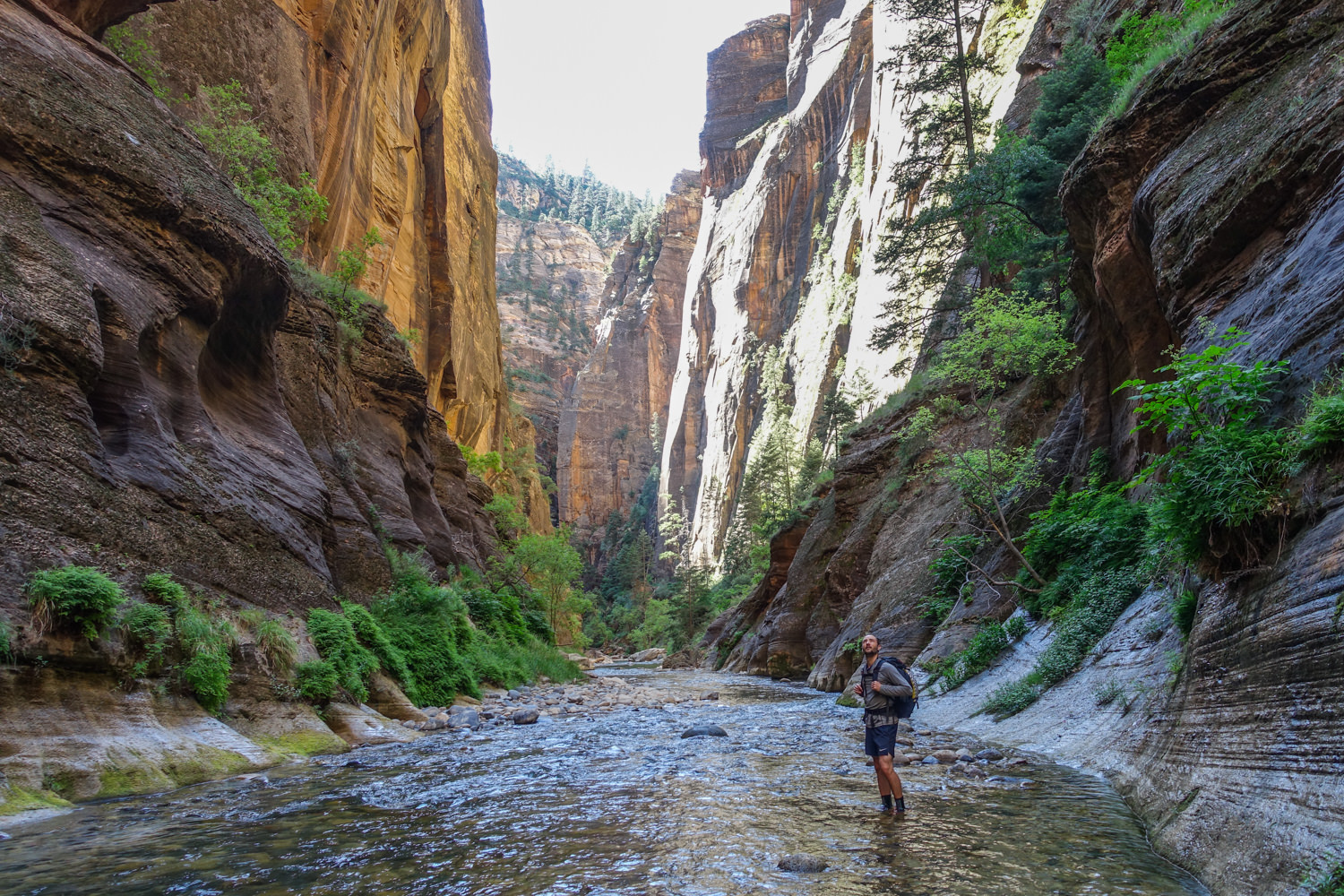
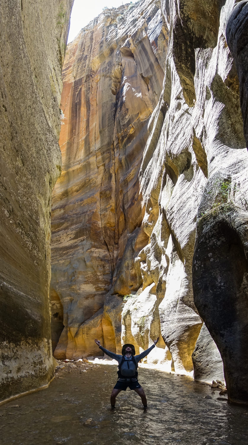
Few things compare to splashing 16 miles through a narrowing natural hallway. Ambitious hikers with river-fording experience can do all 16 miles in a very long day, but the best way to experience the iconic canyon’s spectacular beauty and solitude is to spend a night. The highlight comes on Day 2, where sheer walls of sandstone reach thousands of feet above the North Fork of the Virgin River, framing blue slivers of sky and lush, hanging gardens of fern, moss, and monkey flowers.
Based on our personal experience, our guide shares how to backpack the Zion Narrows top-down over two memorable days.
Quick Facts
- Distance: 16 miles
- Days Needed: 2 days
- Elevation Gain/Loss: -1,410 feet net elevation loss
- Best Travel Time: Mid-May through Mid-October
- Permits: Yes, very competitive
- Difficulty: Moderate to Difficult
- Shuttle Available: Yes
Highlights
- Gorgeous slot canyon
- Good balance of sun and shade
- Well-spaced campsites
- Lower congestion due to limited permits
- Constant source of water to keep you cool
- Quiet nights
Lowlights
- Possibility of dangerous flash floods
- Highly competitive permit system
- No bail out points
- Constant wading and slick rocks can be tough on feet
- Deep pools occasionally require swimming or chest-deep fords
- Few wildlife sightings
Best Time to Travel
The best times to visit The Narrows are mid-April to June and late September to mid-October. That’s when the temperatures are cooler, and the risk of flash floods is lower.
For experienced hikers who are tuned into heat risks, it’s quite doable in June through September because the river will help cool off overheated bodies. It’s also a little easier in the summer because water levels are lower, rarely rising above the knees.
Flash floods
Flash floods are a serious concern in the Narrows that you should not take lightly.
Floods pose a bigger risk in early and late summer, when thunderstorms are common. It’s not unheard of for such storms to unload up to 4 inches of rain in 15 minutes.
Flash floods in the Zion Narrows can be fatal for day hikers and backpackers.
If the areas above the canyon receive rain, the runoff water quickly flows down gullies and washes to flood the slot canyons below. When this happens at the Narrows, the runoff triggers a life-snuffing wave that knocks down everything in its path. With no bailout points inside The Narrows, there’s virtually no way for hikers to escape these floods.
That’s why the park service automatically closes The Narrows when the National Weather Service delivers a Flash Flood Warning – and keeps it closed for two hours after the warning is lifted. It also rescinds permits when flows exceed 120 cubic feet per second to protect backpackers from flash floods.
Before you venture into the Zion Narrows, check water volume data at the Virgin River Flow Gauge and keep an eye on current weather and forecast. Keep in mind that flooding is possible at any time. Floods have occurred on days they were not forecasted. As the park service reminds you when you get your permit, your safety is your responsibility.
Difficulty
- Total Distance: 16 miles
- Total Elevation Gain/Loss: -1,410 feet net elevation loss
- Overall Difficulty: Moderate to Difficult
As always, difficulty ratings depend on your experience, physical fitness, pack weight, and weather conditions. Seasonal rainfall and snowfall significantly impact water level, which fluctuates daily, weekly, monthly and yearly. The Narrows is mostly a moderately difficult trip when the river is running below 70 cubic feet per second (CFS). Most fords are knee deep but also across slippery, uneven river bottoms with occasional pools up to waist deep. Above 70 CFS, crossings get much more difficult – particularly walking against the current.
As always, know your limitations, brush up on your skills, and dial in your lightweight gear. Doing so will make for a safe and enjoyable adventure.
Permits
Whether you plan to day hike or backpack The Narrows, you need a wilderness permit for any travel above Big Spring (which is just under halfway up the main gorge of The Narrows). There are three ways to get a permit: advance reservations, daily lottery (for day trips only), or walk-up permit.
Zion National Park uses recreation.gov to issue permits for the Zion Narrows. They release 24 of the 40 available day hike permits for advance reservations. Overnight reservations are limited by number of campsites and their capacity. (There are 12 sites: 6 sites are reservable and 6 are for walk-ups). A helpful NPS map shows the campsites.
Reservations are available online up to three months before your trip date. They become available the fifth day of every month at 10 am Mountain Time. So, for a trip in June, you can look for permits starting April 5, for July permits on May 5, and so on.
If advance reservations for day trips are fully booked online, the Daily Lottery becomes an option. The National Park Service reserves 16 permits for the daily lottery.
To get this permit (called the Zion National Park Canyoneering Daily Lottery), submit an online application two days before your preferred date. The lottery opens at 12 am (midnight) MT and closes at 3 pm MT. It doesn’t matter what time you apply: everyone has equal chances. The Park Service notifies lottery winners at 4 pm.
The lottery costs $6 to enter. Successful lottery entries will be charged an additional $10 per person when they pick up their permit at the Wilderness Permit Desk in the Zion Canyon Visitor Center or when they “Claim” the permit in their rec.gov account.
If spaces remain after the Daily Lottery, Walk-in Permits become available one day before your desired trip. Half of the backpacking sites are also available as walk-up permits, which hikers obtain at park visitor centers the day before your trip.
Permit Costs
- $ 16.00-day trip permit ($6 permit fee and $10 per person)
- $27.00-overnight permit ($20 permit fee and $7 per person)
Frequent visitors to Zion should consider enrolling in the Zion Express Membership. It allows members who have obtained a reservation to convert it to a permit online three days before their trip. There’s no cost to enroll, no waiting in line to pick up permits, and reservation fees are applied to the cost of the permit. The entire permit process can be completed online.
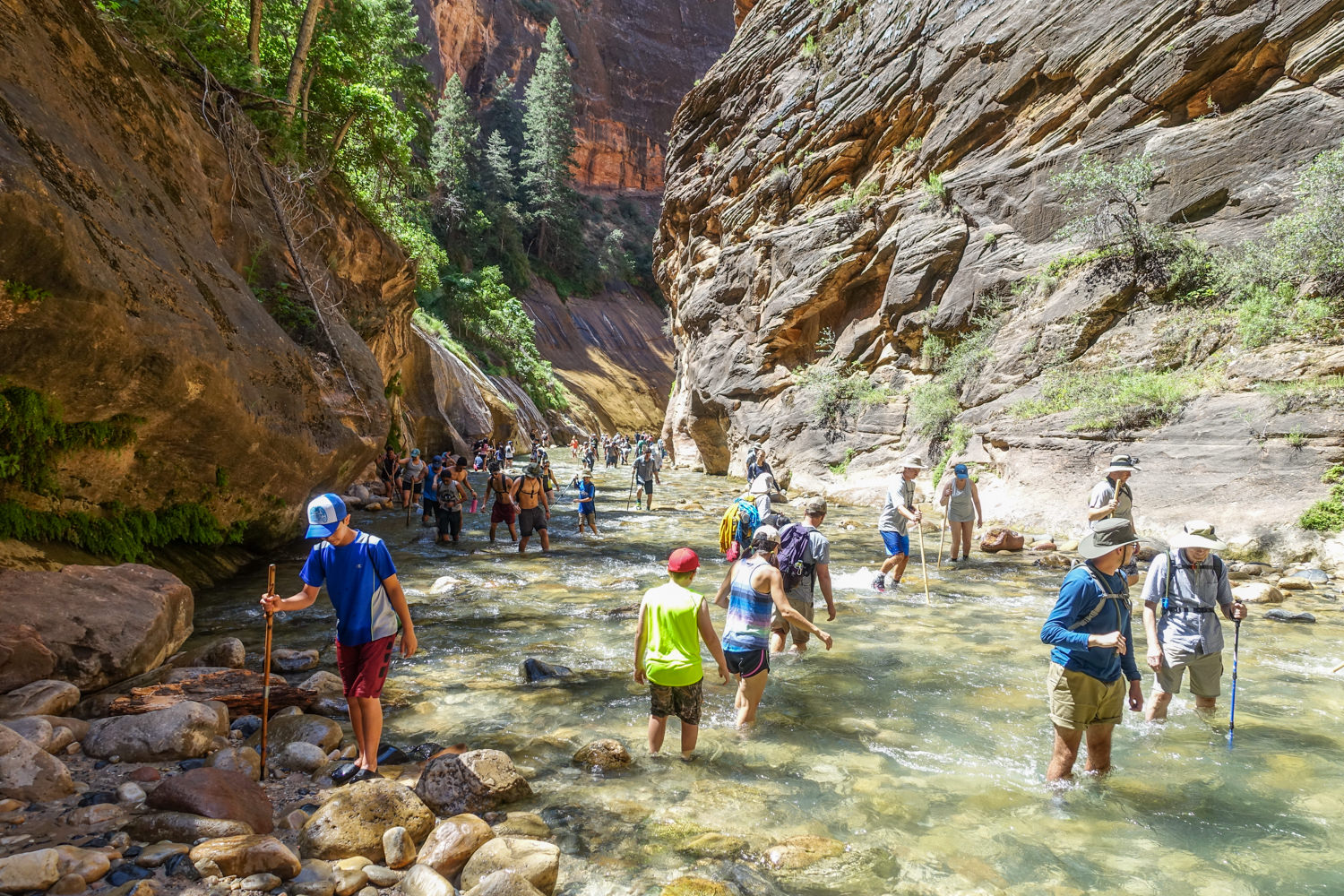
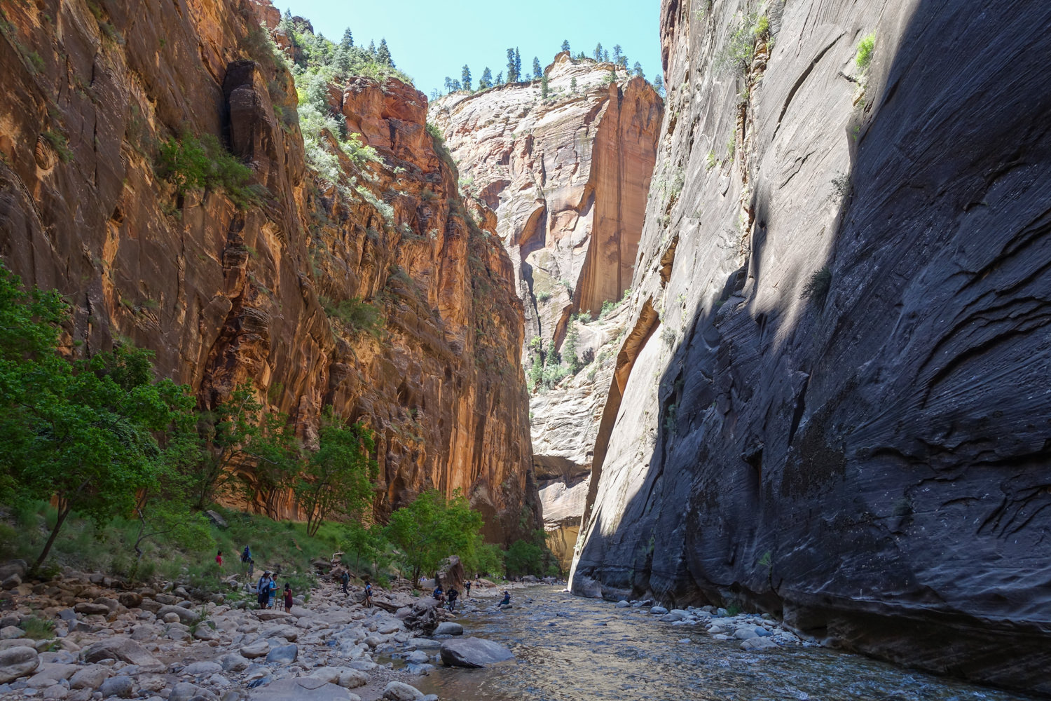
Solitude
Starting at the bottom (Temple of Sinawava), the first few miles from the trailhead are as crowded as a New York subway. Still, the scenery is immediately gorgeous. Hiking top-down delivers untold dividends in solitude along with mile after mile of sheer jaw-dropping beauty.
Itinerary
Chamberlin Ranch trailhead
The hike starts at Chamberlain Ranch – a private cattle ranch located along the North Fork of the Virgin River. When you reach the ranch, look for the trailhead just south of the Virgin River after a brief stream crossing (just past the Narrows information sign).
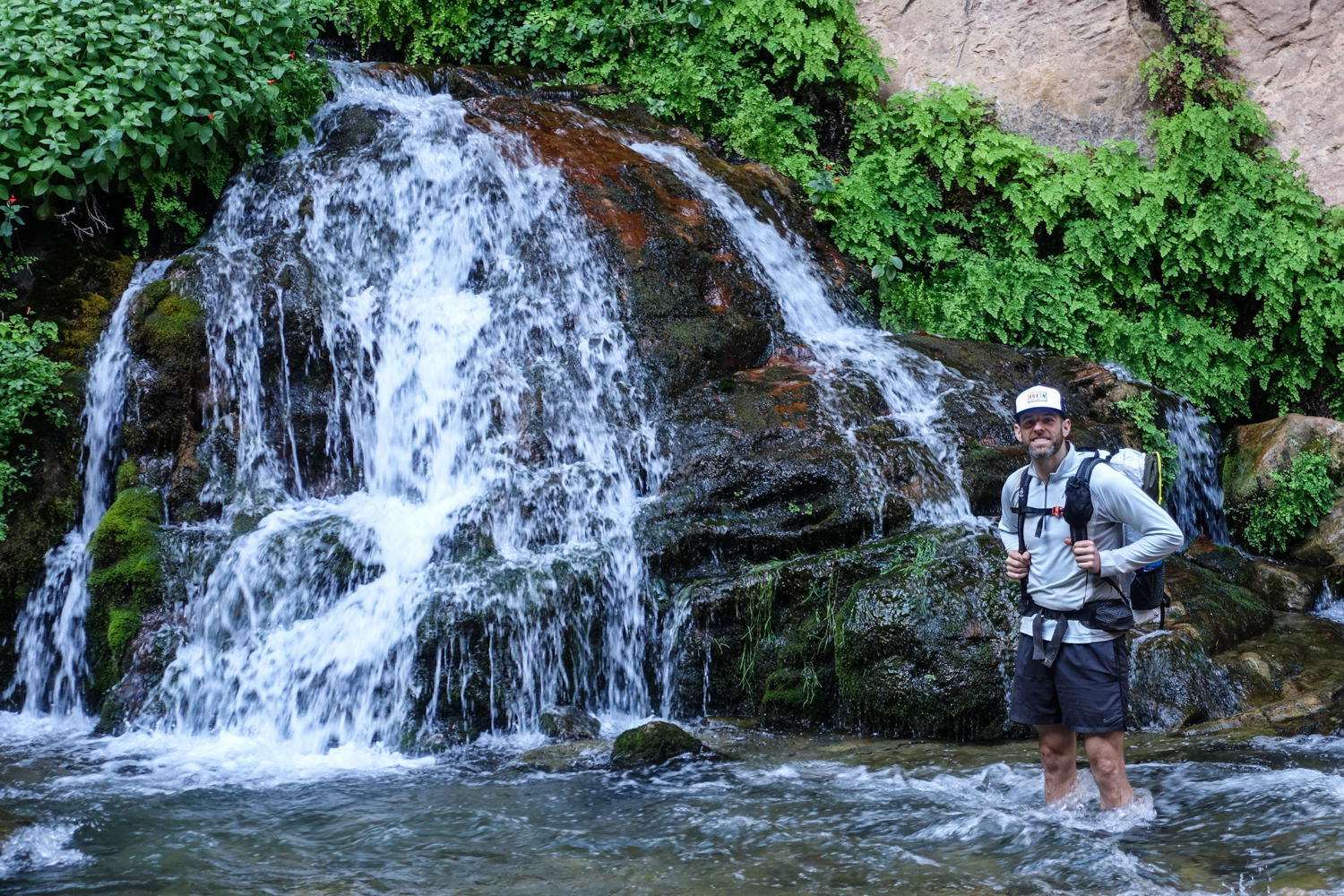
From here, you hike approximately three miles through arid pastures before you technically reach “The Narrows.” At the trailhead, take the smart dirt road across the river and continue west along the bank.
The dirt road route borders a desert forest of juniper and piñon pine with electric fences holding back grazing cows. At 2.5 miles, you’ll encounter an old, dilapidated homestead called Bulloch’s Cabin. From there, go about 200 yards further and take one of the trails heading eastward toward the stream. (There are a scattering of trails—all eventually lead into the stream bed of the North Fork of the Virgin River.)
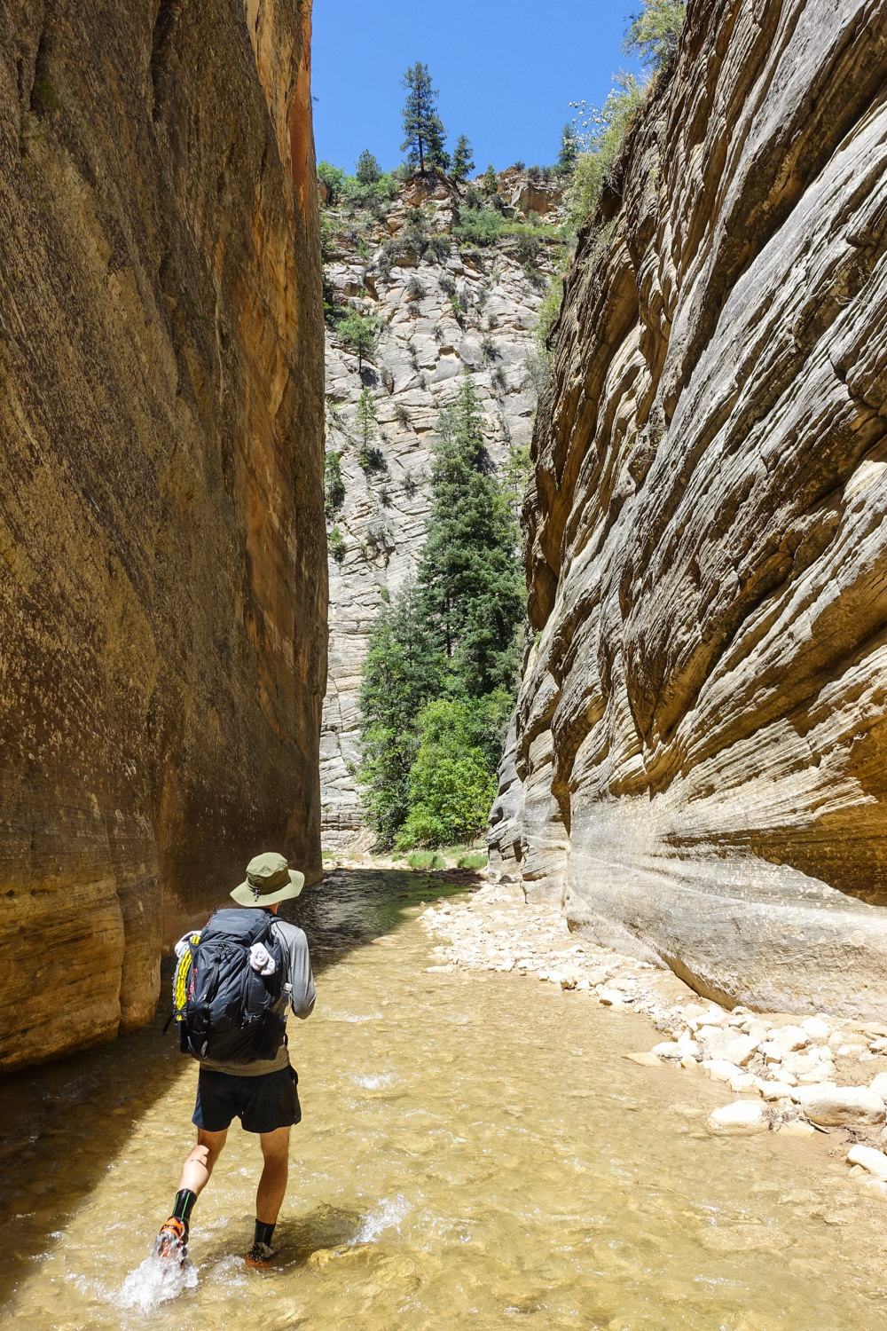
At this point, it’s clear that you’re entering the canyon. Before long, the walls begin to rise. From here on out, you’re in and out of water for the next 13 miles.
Mile 6.45
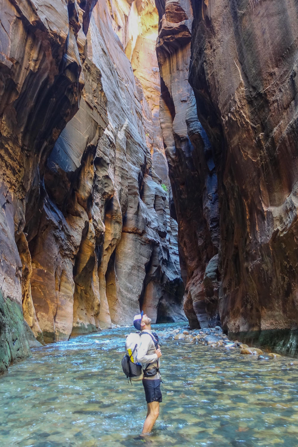
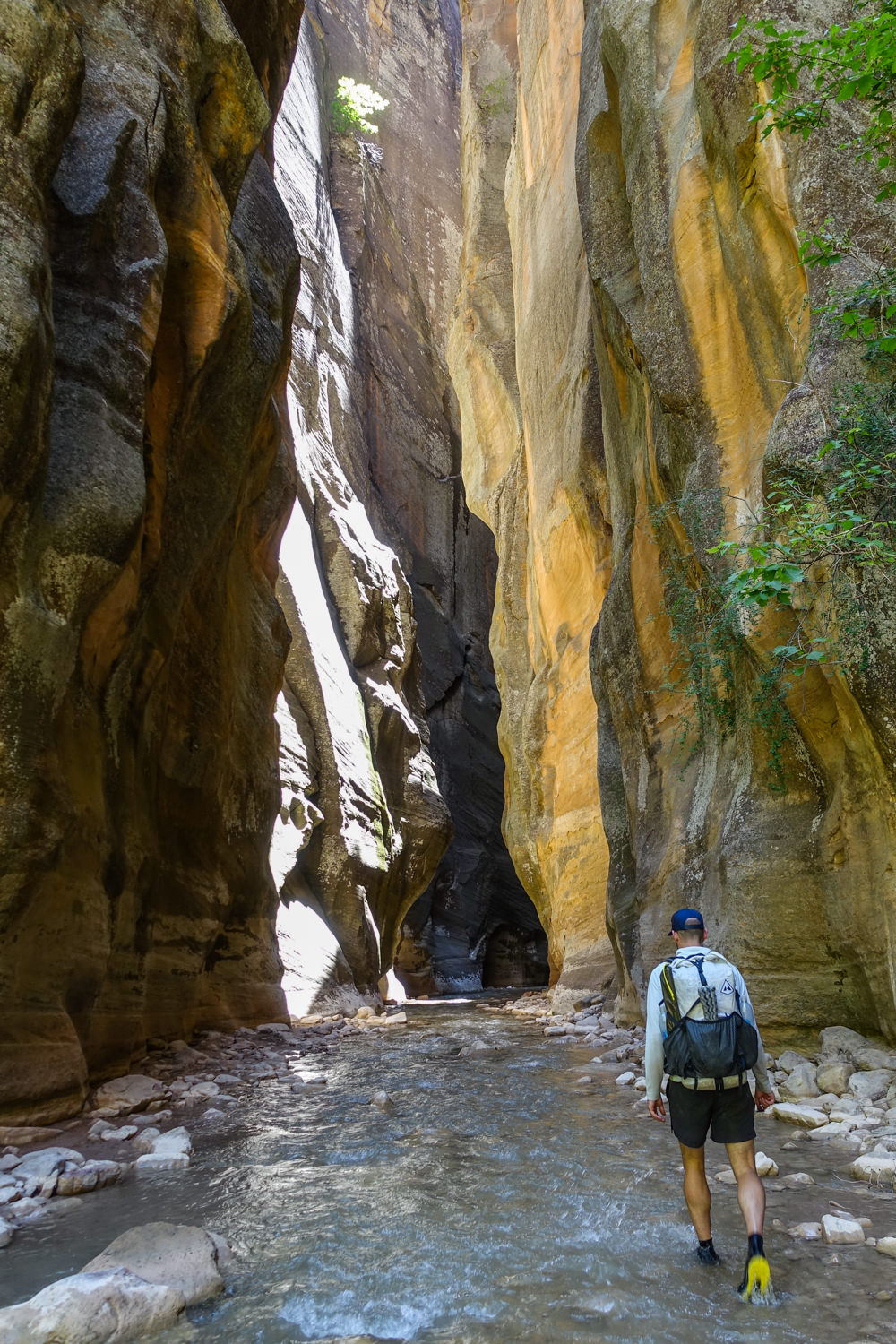
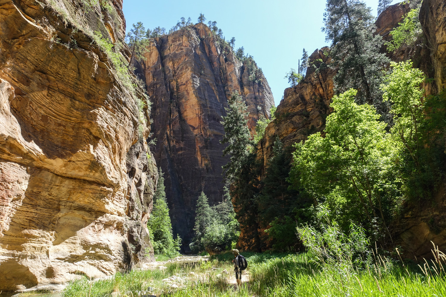
Here’s where the constricting walls give the Narrows its eponymous name. In places, you can reach out and touch both walls of the narrowing gorge. The route traverses river and riverbank. This section mostly follows a well-defined trail along the riverbank with only short fords through the water.
Mile 8.66
Just upstream of this mileage, you’ll work your way around a sketchy traverse by a cascading waterfall and then finally arrive at the confluence of Deep Creek. This is one of the Virgin River’s most significant tributaries – where water levels and CFS increase about three-fold. This means deeper crossings and more challenging currents.
Mile 10.68
Just below the confluence of Goose Creek, things get even more challenging. Expect a slower pace as pools deepen, detours steepen, and slick down climbs impede speedy foot travel.
Mile 11.31
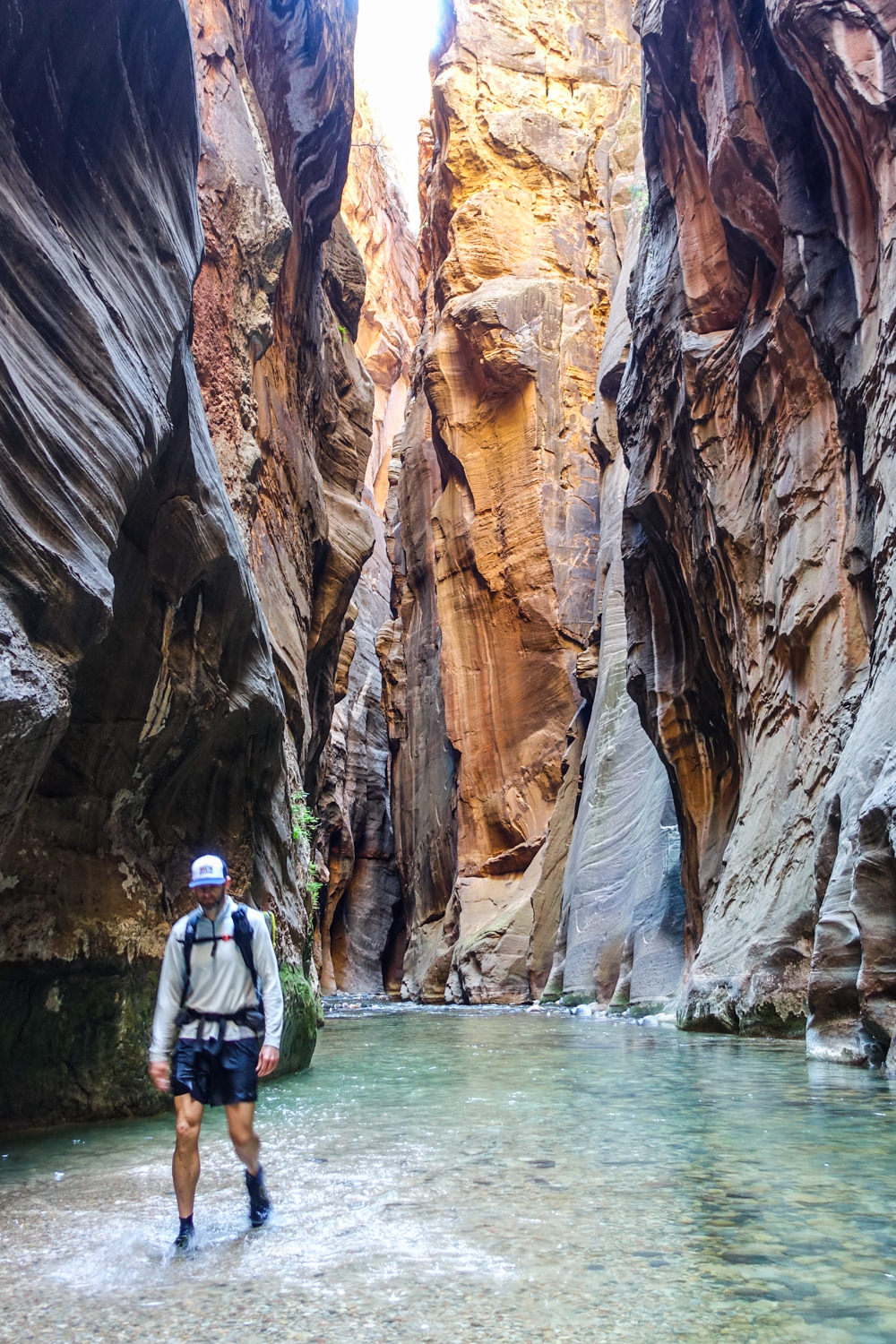
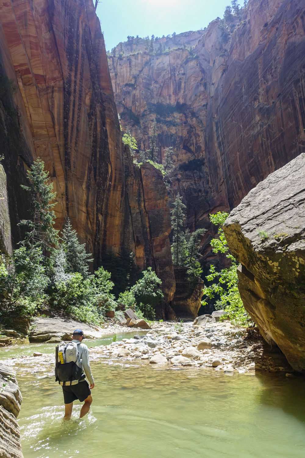
You’ve arrived at Big Spring. From this point on, you’re continually in the water for two miles until reaching the Orderville Canyon confluence. You’re sometimes wading chest-deep water and sometimes swimming. This is easily the most dangerous part of the hike – with few high-ground escapes from floods and high water.
Mile 13.33
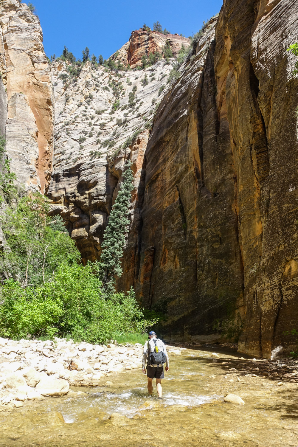
Orderville Gulch, Mystery Canyon, and Zion Stadium are where you’ll start seeing more sunlight – and hordes of day hikers. The steady uptick of people will continue to increase as you get closer to the exit at the Temple of Sinawava trailhead.
The good/bad news is that the level dirt trail gets a lot easier and faster as you near the end of your adventure.
Getting To the Trailhead
Chamberlain’s Ranch Trailhead (also known as the Zion Narrows Upper Trailhead) is a 1.5-hour drive from inside the park and the Temple of Sinawava trailhead. The trailhead is outside the park, so the park’s shuttle system doesn’t run there.
To get to your starting point, drive 2.5 miles east on Route 9 from Zion National Park’s East Entrance. Take a left on the paved route that goes north. Continue 18 miles to a bridge crossing the Virgin River’s North Fork.
The route starts out paved but switches to gravel along the way. Just past the bridge, turn left and drive .25 miles to Chamberlain’s Ranch Gate. You may need to open it. (If so, be sure to close it behind you. We don’t want to let the cows out.) Drive another half-mile and park just before the road crosses the river.
Sedans can usually make it to the ranch in dry weather, but things can get dodgy fast when rain falls. The unpaved road becomes very slick with mud, and snow closes the road entirely in winter.
Shuttle Options
You’ll need to take a shuttle service, hire someone to drive you, or take two cars and shuttle yourself to hike this route. Using two cars is the most economical, but it’s also very time consuming (3-hour shuttle).
Commercial shuttle services are available to Chamberlain Ranch. When last we checked, fees ranch from $60 – $85 per person. Seating is often limited, so it’s best to nail this down well in advance of your departure date.
- Zion Rock and Mountain Guides: 435-772-3303
- Red Rock Tours: 435-635-9104
- Zion Adventures: 435-772-0990
- Zion Guide Hub: 435-414-8040
More than likely, you will use the park shuttle system to exit at the Temple of Sinawava. The Zion Canyon Scenic Drive is closed to private vehicles whenever the shuttle service is operating. This just means you’ll leave a vehicle at the Visitor’s Center and bus from the trailhead to your car.
The park shuttle service usually begins the first week of March (e.g., March 3rd in 2026) and runs through November. However, the National Park Service adjusts this schedule each season. We recommend calling the Visitor Center or checking the current schedule to confirm dates and hours.
Campsites
The Narrows offers 12 numbered sites. The National Park Service only allows one-night stays and requires a top-down traverse from Chamberlain’s Ranch to Temple of Sinawava (vis-a-vis) The River Walk Trail.
Register for a campsite when you pick up your Zion backcountry permit. Pre-registrations are recommended for weekend trips. Campsite capacity is limited, and only two sites can accommodate groups of more than 6 individuals.
There’s really not a bad one out of the whole lot. If anything, you should select a campsite that matches your group size. The following is a list of campsites and size:
CAMPSITE #1: Maple Falls (also called Deep Creek) – 4 people
Just before you reach Campsite 1, the river dives over a 12-foot waterfall, which you can bypass by staying left and hiking up and over a steep and narrow but well-defined path. The campsite is downstream of the falls on a fairly flat spot near the Deep Creek confluence. You can reserve it in advance.
CAMPSITE #2: River Bend – 4 people
Located on the right side of the river just past a waterfall about 10-15 minutes from the Deep Creek site. Look for a sharp bench about 10 feet above the river.
Over the next two to three miles, there are 10 more campsites downstream – about a 10-15 minute walk from each other. Keep an eye out for campsite markers because they’re not al ways obvious. Walk-up permits only.
CAMPSITE #3: River Bench – 6 people
Another 10-15 minute walk and located on the right hand bench in a small stand of maple trees about 20 feet above the river. Reserve online.
CAMPSITE #4: Flat Rock – 2 people
Look for a large flat rock next to the river about 10 minutes downstream from Campsite #3. The site is up on a bench about 6 feet above the river next to the canyon wall. Walk-up permit only.
CAMPSITE #5: RingTail – 6 people
About 5 minutes downstream from Flat Rock, look for a sandy area on the bench to the right just before Kolob Creek confluence. Reserve online.
CAMPSITE #6: Kolob Creek – 12 people
Also on the right about 20 feet above the river on a bench. Walk-up permit only.
CAMPSITE #7: Box Elder – 6 people
10 minutes downstream from Kolob Creek, this site is located on the left on a bench about 30 feet above the river. Reserve online.
CAMPSITE #8: Boulder Camp – 6 people
Across the river from Box Elder, around a sharp bend, follow the trail on the right up slope for about 50 feet. Walk-up permit only.
CAMPSITE #9: Left Bench – 6 people
This one is on the left, about a 10-minute hike beyond Boulder Camp on a 10-foot bench next to the canyon wall, also in a grove of maples. It’s easy to miss. Reserve online.
CAMPSITE #10: West Bend – 6 people
Located near Goose Creek, which is about 1.3 miles past the confluence with Kolob Creek, and only 5 minutes from Left Bench. This campsite sits on a high bank on a westward bend of the river. Walk-up permit only.
CAMPSITE #11: Spotted Owl – 4 people
The sunniest of all the sites, it’s up a slope 10 feet above the river on the left side, immediately after the first stream crossing. Walk-up permit only.
CAMPSITE #12 High Camp – 12 people
Travel another 15-20 minutes (it’s a particularly challenging route) to find the next campsite, which is about 300 yards upstream from Big Spring. Look up on the left side of the river to a 25-foot high bench featuring a stand of maple and Douglas fir. Keep in mind that Big Springs is also the typical turnaround spot for day hikers coming up from the Temple of Sinawava. Reserve online.
Day Hiking Options
TOP TO BOTTOM
You could choose to walk the entire length of the Narrows in one day – but calling it grueling would be an understatement. In ideal conditions, experienced hikers need 10-14 hours to cover the 16-mile route.
Wilderness permits are required to enter and hike the Narrows. As with overnights, they are not issued when the flow is 120 cfs or greater.
You’ll still need two cars or a shuttle for the day hike. (Keep in mind that a self-shuttle tacks 3 additional hours onto 10-14 hours of hiking.)
BOTTOM-UP HIKE FROM THE TEMPLE OF SINAWAVA TO BIG SPRING
You won’t need a permit to hike the Narrows upstream as far as Big Spring and back – which is a strenuous, all-day adventure (10-mile round trip). This option allows you to see some of the most spectacular and narrowest parts of the canyon, but you’ll miss out on the incredible solitude an overnight experience in the canyon provides. This route is also very crowded during the shoulder and peak season.
Maps & Guidebooks
To date, there are no specific guidebooks detailing just the Narrows. However, several regional books cover it as part of their overall coverage of Utah or Zion National Park. As far as maps go, the USGS 7.5-minute topographical maps Straight Canyon, Clear Creek Mountain, and Temple of Sinawava all show the Narrows.
- Zion National Park Trails Illustrated Topographic Map – A highly researched and detailed 1:37,700 scale map that includes a chart detailing the extraordinary geology of Zion and a companion hiking timetable for The Narrows. It also has information on trailheads, campsites and mileage. (Bonus: Every Trails Illustrated map is printed on “Backcountry Tough” waterproof, tear-resistant paper. A full UTM grid is also printed on the map to aid with GPS navigation).
- Lonely Planet Zion and Bryce Canyon National Parks – If you are doing more hiking in the area, this Lonely Planet guide offers in-depth information on various of hiking and backpacking options and a wealth of other useful planning tips.
- Water, Rock, & Time –The Geologic Story of Zion National Park by Robert L. Eves Learn how the landscape of Zion was created through the ongoing processes of geology. You’ll also learn about the main rock layers, and the role of water in carving and shaping the slot canyons, including The Narrows.
- We use Caltopo to research trips, plan routes, and print maps for many of our backpacking adventures. It takes a little time to learn the tool, but it’s an excellent resource.
- We use Gaia GPS for on-trail navigation on most of our backpacking trips. We always bring a topo map and compass, but Gaia is an excellent tool in the field. GPS signals can be very hard to come by when the canyon walls are steep, but may be possible in wide sections.
- NPS- Plan Your Visit – Here’s a good planning primer from Zion National Park. You can also and find up-to-date information on The Narrow’s conditions and regulations.
Water
We recommend following the National Park Service’s guidance on water sources at Zion.
Zion’s backcountry staff warns against drinking water from rivers and streams due to toxic cyanobacteria in these waters. No recreational filters or treatments can beat this nasty and unfortunate bloom. Spring water is okay to drink once treated and filtered.
They encourage hikers to carry in all of their water. Having said that, they also recommend drinking one gallon per person per day, which is a lot of water weight on your back.
For our trip, we carried a gallon of water to get to Big Spring. We then filled up with treated water from this spring for our day out.
The National Park Service recommends treating spring water (not water from the North Fork of the Virgin River) by bringing it to a roiling boil for three minutes to kill pathogens.
We often use chemical water treatments in the desert, such as chlorine dioxide tablets or drops. If you prefer to double down and filter your water, check out our water purification guide for more info and gear recommendations.
Human Waste
Desert ecosystems require people to be more diligent to protect fragile water sources. Here are the two rules to remember when hiking the Zion Narrows (and desert ecosystems in general):
- Pee in the water – not on plants or soils.
- Carry human waste disposal bags to pack out your solid waste.
The backcountry staff will hand you a Restop 2 compostable human waste disposal bag when you pick up your permit. Also called “Wag bags,” they’re essentially oversized Ziplocs that contain compostable polymers that instantly break down waste and turn it into a deodorized gel. These leak-proof bags are easy to use, sanitary, and very secure to transport in your pack. You just throw it in the trash on exit.
It’s the best option to protect the Virgin River from human pollution and to keep campsites safer for people. (Even with this carry out policy, the water in the Virgin River is too polluted for human consumption – even with filters and chemical treatments.)
Please take these small steps to protect this irreplaceable natural area – and its life-sustaining water. With so many visitors to Zion National Park, it only takes a few stupid, selfish individuals to ruin campsites and contaminate water sources that people and animals rely upon in this fragile desert ecosystem. If you love nature, do your small part to preserve this special place.
Gear List
Make sure to check out our Ultimate Backpacking Checklist, so you don’t forget something important.
Below you’ll find our current favorite backpacking gear. If you want to see additional options, our curated gear guides are the result of many years of extensive research and hands-on testing by our team of outdoor experts.
BACKPACK
- Best Backpacking Pack Overall: Gregory Paragon 58 – Men’s / Gregory Maven 58 – Women’s
- Best Ultralight Backpacking Backpack: Hyperlite Mountain Gear Unbound 40
- More: Check out our best backpacking backpacks guide for ultralight and trekking options
TENT
- Best Backpacking Tent Overall: Big Agnes Copper Spur HV UL2
- Best Ultralight Tent: Zpacks Duplex
- Best Budget Tent: REI Half Dome 2
- Best Tent Stakes Overall: All One Tech Aluminum Stakes
- More: Check out our best backpacking tents guide for more options
SLEEPING BAG/QUILT
- Best Sleeping Bag Overall: Men’s Feathered Friends Swallow YF 20 / Women’s Feathered Friends Egret YF 20
- Best Quilt Overall: Enlightened Equipment Revelation 20
- More: Check out our best backpacking sleeping bags guide and best backpacking quilts guide for more options
SLEEPING PAD
- Best Sleeping Pad Overall: NEMO Tensor All-Season
- Best Foam Sleeping Pad: NEMO Switchback
- More: Check out our best backpacking sleeping pads guide for ultralight and trekking options
CAMP KITCHEN
- Best Backpacking Stove Overall: MSR PocketRocket 2
- Best Backpacking Cookware Overall: TOAKS Titanium 750ml
- Best Backpacking Coffee Overall: Starbucks VIA
- More: Check out our best backpacking stoves guide and best backpacking cookware guide for ultralight and large group options
WATER & FILTRATION
- Best Water Filter Overall: Sawyer Squeeze
- Best Hydration Bladder Overall: Gregory 3D Hydro
- Best Backpacking Water Bottles: Smartwater Bottles
- More: Check out our best backpacking water filters guide and best backpacking water bottles guide for ultralight and large group options
CLOTHING
- Best Hiking Pants Overall: Men’s Outdoor Research Ferrosi / Women’s The North Face Aphrodite 2.0
- Best Hiking Shorts Overall: Men’s Patagonia Quandary / Women’s Outdoor Research Ferrosi
- Best Women’s Hiking Leggings: Fjallraven Abisko Trekking Tights HD
- Best Rain Jacket Overall: Men’s Patagonia Torrentshell 3L / Women’s Patagonia Torrentshell 3L
- Best Rain Pants: Men’s Patagonia Torrentshell 3L / Women’s Patagonia Torrentshell 3L
- Best Down Jacket Overall: Men’s Patagonia Down Sweater Hoodie / Women’s Patagonia Down Sweater Hoodie
- Best Fleece Jacket Overall: Men’s Patagonia Better Sweater / Women’s Patagonia Better Sweater
- Best Sunshirt Overall: Men’s Outdoor Research Echo / Women’s Outdoor Research Echo
- Best Socks Overall: Men’s Darn Tough Light Hiker Micro Crew / Women’s Darn Tough Light Hiker Micro Crew
- Beste Ultralight Liner Glove: Patagonia Capilene Midweight Liner
- More: Check out our best backpacking apparel lists for more options
FOOTWEAR & TRACTION
- Best Hiking Shoes Overall: Men’s HOKA Speedgoat 6 / Women’s HOKA Speedgoat 6
- Best Hiking Boots Overall: Men’s Salomon X Ultra 5 GTX / Women’s Lowa Renegade Evo GTX
- Best Hiking Sandals Overall: Men’s Chaco Z/1 Classic / Women’s Chaco Z/1 Classic
- Best Camp Shoes Overall: Crocs Classic Clogs
- Best Traction Device for Hiking Overall: Kahtoola MICROspikes
- More: Check out our best backpacking footwear lists for more options
NAVIGATION
- Best GPS Watch Overall: Garmin Instinct 2 Solar
- Best Personal Locator Beacon (PLB): Garmin inReach Mini 2
- More: Check out our article How to Use Your Phone as a GPS Device for Backpacking & Hiking to learn more
FOOD
FIRST-AID & TOOLS
- Best First-Aid Kit Overall: Adventure Medical Kits Ultralight/Watertight .7
- Best Pocket Knife Overall: Kershaw Leek
- Best Multitool Overall: Leatherman Wave+
- Best Headlamp Overall: Black Diamond Spot 400-R
- Best Power Bank Overall: Nitecore NB 10000 Gen 3
- More: Check out our best first-aid kit guide, best pocket knife guide, best multitool guide, best backpacking headlamps guide, and best power banks guide for more options
MISCELLANEOUS
- Best Trekking Poles Overall: Black Diamond Pursuit
- Best Backpacking Chair Overall: REI Flexlite Air
- Best Backpacking Stuff Sack Overall: Hyperlite Mountain Gear Drawstring
- More: Check out our best trekking poles guide, best backpacking chairs guide, and best stuff sacks guide for more options
Special Canyoneering Gear Considerations
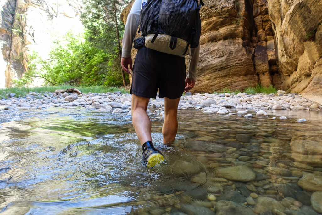
Footwear
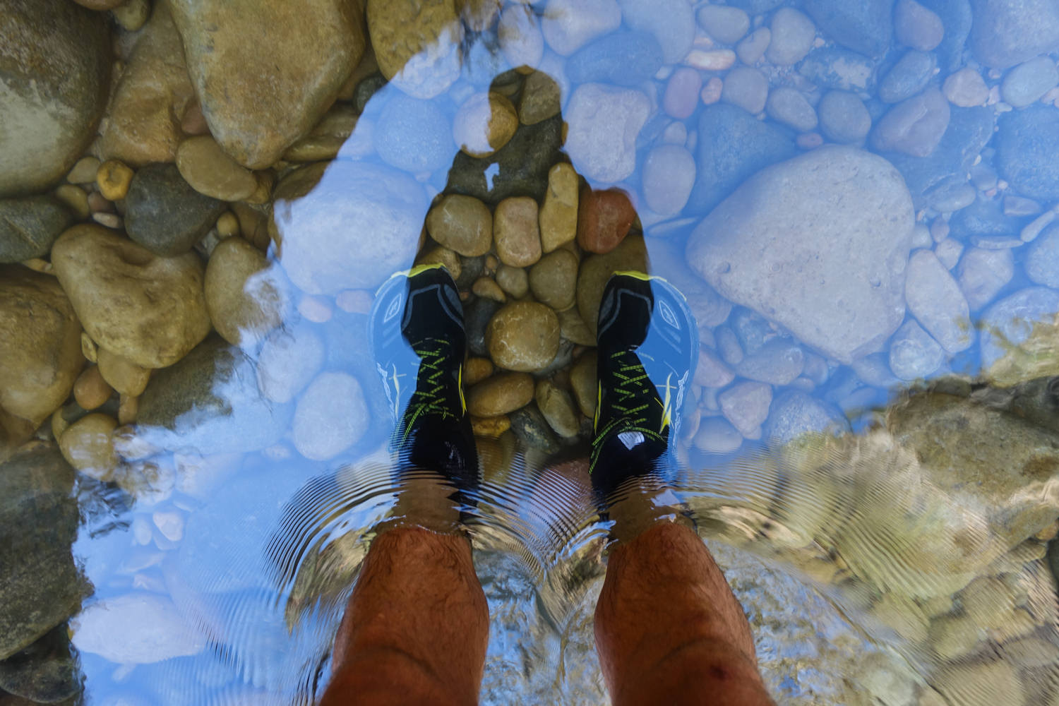
Footwear is a somewhat complicated choice for this trip. You’ll be spending a good portion of this hike in water, so your shoes will be wet for the entire trip. Footing is the biggest challenge in riverbeds and on the steep banks along the river. Also, water temperature at certain times of the year can be very cold, so 2-3mm neoprene water socks are highly recommended.
Because of the slick and rocky riverbeds, many hikers prefer sturdy, lightweight, quick-draining shoes. It’s uncommon for hikers to own this specific type of footwear, so many rent them from one of the gear equipment shops in Springdale before their trip.
If you have strong ankles, tough feet, and lots of river fording experience, it’s also possible to hike this trip in trail running shoes, but that’s a personal choice. We hiked this trip in trail runners with neoprene socks to help keep our feet warm, and it worked out well for us.
We would definitely not recommend hiking this route in open-toe sandals, though some do. In our opinion, you’ll at very least want closed-toe trail running shoes to protect your feet from getting torn up on the river rocks.
Dry bags
For a good portion of this trip, you’ll be wading and fording rivers – sometimes waist- and chest-deep, depending on the time of year. Very few (if any) backpacking packs are fully waterproof, so we recommend packing all your items in individual dry bags, such as HMG roll-top stuff sacks and S2S eVAC Dry Sacks.
Other Special Gear Considerations
We cannot overemphasize how important it is to prepare for desert sun conditions. Sunglasses (polarized recommended), sunscreen, and SPF lip balm are all critical on this trip.
Regardless of daytime temperatures, warm fleece clothing is essential, as evening temperatures in the canyon can drop significantly. When you’re cold and wet, you need warm and dry clothing. Day hikers should also be prepared for the drastic temperature drops in the late afternoon and early evenings.
Quick-dry clothing is essential for this trip. Forget cotton, which gets soggy and draws heat away from the body. Synthetics are your friend in The Narrows. Wool, especially hybrid merino, can be useful for keeping you warm but still takes longer to dry than synthetics. In the winter or shoulder season (as late as mid-May), you may want to consider a dry suit.
Although we don’t usually hike with trekking poles, they would be handy on this type of trip. Fording rivers will test your balance, especially when moving against currents with slippery rocks underfoot. Check out some of our lightweight recommendations on our Best Trekking Poles list.
More Information
We hope this CleverHiker trip guide helps you plan an incredible adventure through the slot canyons of the Narrows trail in Zion National Park. For more CleverHiker recommendations on gear and skill building, check out the following links: